My #30DayMapChallenge, 2023
This is my fifth season since the beginning of this challenge.
Results of previous challenges — 2019, 2020, 2021, 2022
You can see many interesting and incredible works under the hashtag #30DayMapChallenge on Social Media.
Results of previous challenges — 2019, 2020, 2021, 2022
You can see many interesting and incredible works under the hashtag #30DayMapChallenge on Social Media.
The official repository for #30DayMapChallenge, It is a daily mapping/cartography/data visualization challenge aimed at the spatial community.
I am incredibly grateful to the wonderful Topi Tjukanov from Helsinki, Suomi for organizing this wonderful and much-needed cartographic holiday. Of course, it is difficult to come up with and make a map every day, but it is definitely worth it!

Maps as a daily beautiful routine #30DayMapChallenge
I survived #30DayMapChallenge fifth time in a row
Here are my new 30 maps about Ukraine. Enjoy!

Day 01: Points. A map with points
Attacks on residential buildings in Ukraine #QGIS #python data from @wikipedia_uk
and OpenStreetMap. Here are only the data recorded by volunteers related to residential architecture. No military objects. Only human housing.
https://twitter.com/gontsa/status/1719835140833063106
https://mastodon.social/@gontsa/111337542592912232

Day 02: Lines. A map with lines
#30DayMapChallenge Area of legal Jewish settlement in the Russian empire from 1791 to 1915. The map shows the situation in relation to the territory of modern Ukraine. This explains a lot in the current historical context. OpenStreetMap Wikipedia
https://twitter.com/gontsa/status/1720145329620656443
https://mastodon.social/@gontsa/111342367004297982

Day 03: Polygons.
#30DayMapChallenge
Є два Львова… The semi-joking story from the Internet meme about the conditional division of the city into two parts is confirmed :-) Lviv is the only major city in Ukraine that is located within two basins of the Black and Baltic seas #QGIS
https://twitter.com/gontsa/status/1720538464448303487
https://mastodon.social/@gontsa/111348506406073327

Let's get this over with
Day 04: A bad map
Day 04: A bad map
#30DayMapChallenge Thoughts on the new ocean.
https://twitter.com/gontsa/status/1720844162117845177
https://mastodon.social/@gontsa/111353284066123514
https://twitter.com/gontsa/status/1720844162117845177
https://mastodon.social/@gontsa/111353284066123514
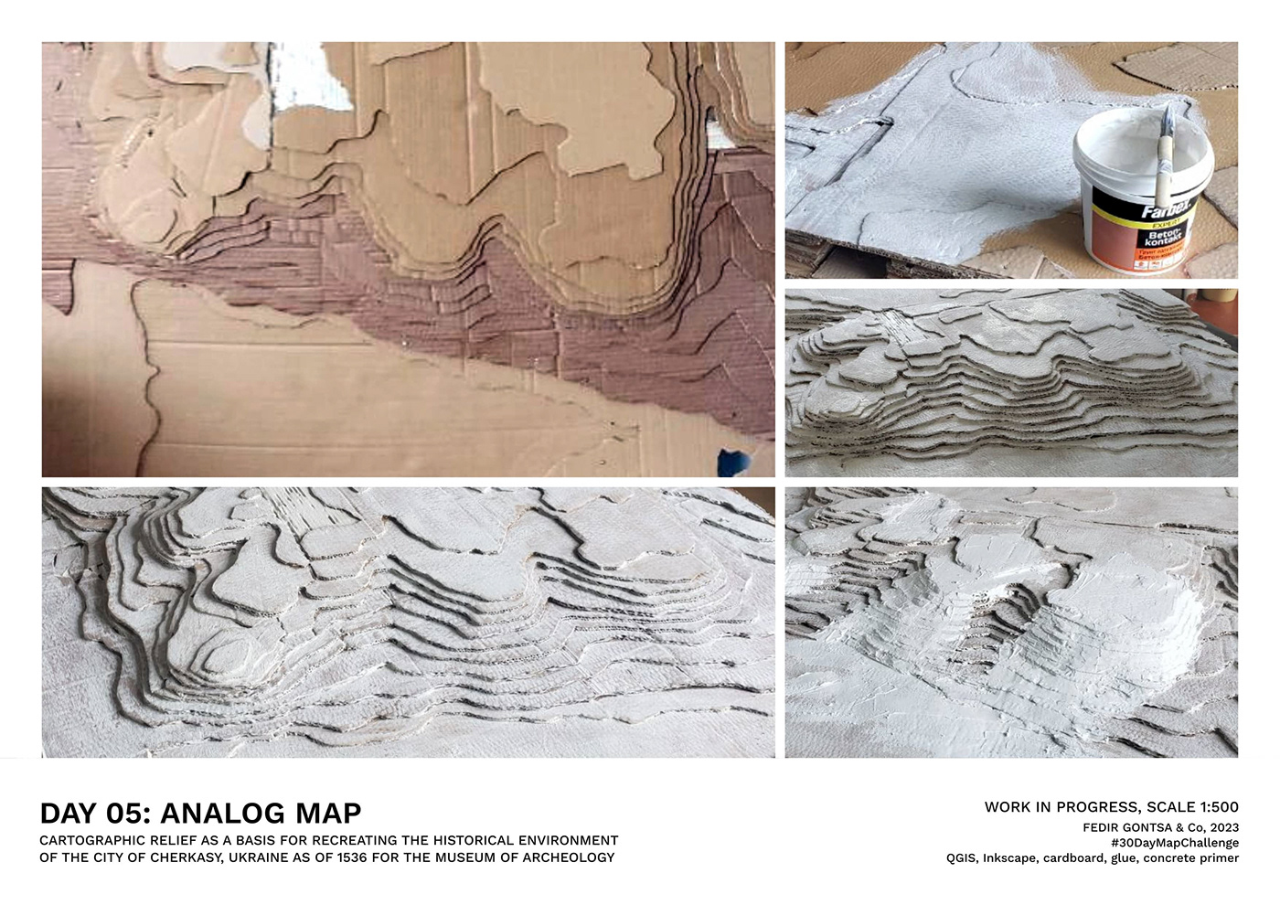
Non-digital maps
Day 05: Analog Map Non-digital maps #30DayMapChallenge
Cartographic relief as a basis for recreating the historical environment of the city of Cherkasy, Ukraine as of 1536 for the Museum of Archeology. Created together with students.
Work in progress, scale 1:500
https://twitter.com/gontsa/status/1721204610461815027
https://mastodon.social/@gontsa/111358978792716092

Largest of the continents
Day 06: Asia
#30DayMapChallenge
Historical Ukrainian diasporas in Asia. All the colors of Ukraine
https://twitter.com/gontsa/status/1721644148166443009
https://mastodon.social/@gontsa/111365781600635143
Day 06: Asia
#30DayMapChallenge
Historical Ukrainian diasporas in Asia. All the colors of Ukraine
https://twitter.com/gontsa/status/1721644148166443009
https://mastodon.social/@gontsa/111365781600635143

A map that helps you to navigate
Day 07: Navigation #30DayMapChallenge
The first great journey of Sofia Yablonska, the first known Ukrainian woman traveler in 1929
Based on the book "Charm of Morocco", 1932.
https://twitter.com/gontsa/status/1722018514129600739
https://mastodon.social/@gontsa/111371627257193238
Day 07: Navigation #30DayMapChallenge
The first great journey of Sofia Yablonska, the first known Ukrainian woman traveler in 1929
Based on the book "Charm of Morocco", 1932.
https://twitter.com/gontsa/status/1722018514129600739
https://mastodon.social/@gontsa/111371627257193238

Day 08: Africa
#30DayMapChallenge
We are very close. We share the same planet #QGIS #b3d #inkscape data: visibleearth.nasa.gov
#30DayMapChallenge
We are very close. We share the same planet #QGIS #b3d #inkscape data: visibleearth.nasa.gov

6 sides, 6 angles, and 6 vertices
Day 09: Hexagons
#30DayMapChallenge
Hexography of Ukraine. Relief of the territory of Ukraine in the form of hexagons
https://twitter.com/gontsa/status/1722725348247318937
https://mastodon.social/@gontsa/111382674497128238
Day 09: Hexagons
#30DayMapChallenge
Hexography of Ukraine. Relief of the territory of Ukraine in the form of hexagons
https://twitter.com/gontsa/status/1722725348247318937
https://mastodon.social/@gontsa/111382674497128238

Northern part of the American continent
Day 10: North America
#30DayMapChallenge
North American cities with a large Ukrainian population
https://twitter.com/gontsa/status/1723143200175473036
https://mastodon.social/@gontsa/111389203972280237
Day 10: North America
#30DayMapChallenge
North American cities with a large Ukrainian population
https://twitter.com/gontsa/status/1723143200175473036
https://mastodon.social/@gontsa/111389203972280237
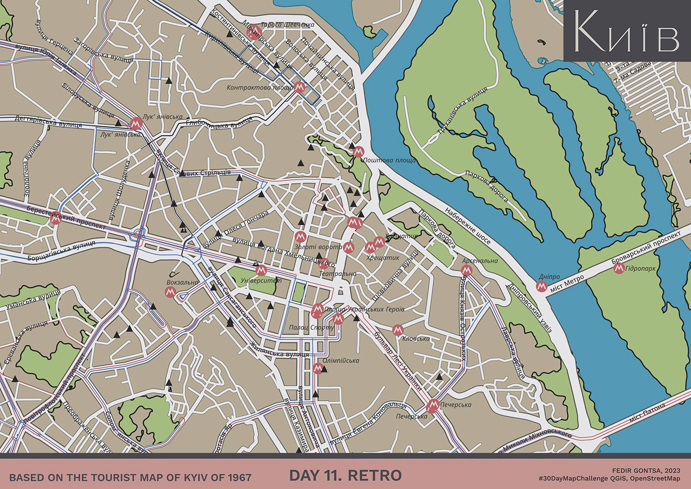
A blast from the past
Day 11: Retro
#30DayMapChallenge
Київ. Based on the tourist map of Kyiv of 1967
Data: OpenStreetMap
https://twitter.com/gontsa/status/1723460306284740908
https://mastodon.social/@gontsa/111394156596885684
Day 11: Retro
#30DayMapChallenge
Київ. Based on the tourist map of Kyiv of 1967
Data: OpenStreetMap
https://twitter.com/gontsa/status/1723460306284740908
https://mastodon.social/@gontsa/111394156596885684
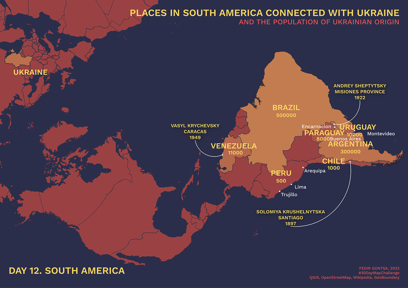
Southern part of the American continent
Day 12: South America
#30DayMapChallenge
Places in South America connected with Ukraine and the population of Ukrainian origin
https://twitter.com/gontsa/status/1723749630498791832
https://mastodon.social/@gontsa/111398678460313257
Day 12: South America
#30DayMapChallenge
Places in South America connected with Ukraine and the population of Ukrainian origin
https://twitter.com/gontsa/status/1723749630498791832
https://mastodon.social/@gontsa/111398678460313257

Classic thematic map: a choropleth
Day 13: Choropleth
#30DayMapChallenge
Ukraine Displacement Data - Returnees
https://twitter.com/gontsa/status/1724185193781612736
https://mastodon.social/@gontsa/111405483950200962
Day 13: Choropleth
#30DayMapChallenge
Ukraine Displacement Data - Returnees
https://twitter.com/gontsa/status/1724185193781612736
https://mastodon.social/@gontsa/111405483950200962

The westernmost peninsulas of Eurasia
Day 14: Europe
#30DayMapChallenge
The biome community of Europe. A biome is a community of plants and animals living together in a certain kind of climate #QGIS
https://twitter.com/gontsa/status/1724575822114095106
https://mastodon.social/@gontsa/111411587778448612
Day 14: Europe
#30DayMapChallenge
The biome community of Europe. A biome is a community of plants and animals living together in a certain kind of climate #QGIS
https://twitter.com/gontsa/status/1724575822114095106
https://mastodon.social/@gontsa/111411587778448612

The greatest of the datasets. Remember to give credit.
Day 15: OpenStreetMap
#30DayMapChallenge
Tagging accessibility information on the #OpenStreetMap in different cities of Ukraine.
Ivano-Frankivsk is the most detailed.
https://twitter.com/gontsa/status/1724961457169744240
https://mastodon.social/@gontsa/111417613348844533
Day 15: OpenStreetMap
#30DayMapChallenge
Tagging accessibility information on the #OpenStreetMap in different cities of Ukraine.
Ivano-Frankivsk is the most detailed.
https://twitter.com/gontsa/status/1724961457169744240
https://mastodon.social/@gontsa/111417613348844533

Region made up of thousands of islands throughout the Central and South Pacific
Day 16: Oceania
#30DayMapChallenge
What do I know about Oceania?
https://twitter.com/gontsa/status/1725288096680296779
https://mastodon.social/@gontsa/111422719416942027
Day 16: Oceania
#30DayMapChallenge
What do I know about Oceania?
https://twitter.com/gontsa/status/1725288096680296779
https://mastodon.social/@gontsa/111422719416942027

Flow of transport, people
Day 17: Flow
#30DayMapChallenge
Ukraine refugee situation
Data from https://data2.unhcr.org/en/situations/ukraine
https://twitter.com/gontsa/status/1725651992519836082
https://mastodon.social/@gontsa/111428402798049521
Day 17: Flow
#30DayMapChallenge
Ukraine refugee situation
Data from https://data2.unhcr.org/en/situations/ukraine
https://twitter.com/gontsa/status/1725651992519836082
https://mastodon.social/@gontsa/111428402798049521

Conditions of the atmosphere can be either weather or climate
Day 18: Atmosphere
#30DayMapChallenge
Fires in Ukraine by year. Data on fires in the first year of russia's full-scale aggression coincide with the sites of combat operations
I couldn't find any interesting data on the atmosphere for my country, so I did something else.
Data https://firms.modaps.eosdis.nasa.gov/country/

Spend no more than 5 minutes to prepare this map
Day 19: 5-minute map
#30DayMapChallenge
Hourly isochrones of Ukrainian cities. Where you can go in 60 minutes by car
https://twitter.com/gontsa/status/1726360749805539350
https://mastodon.social/@gontsa/111439477724928011
Day 19: 5-minute map
#30DayMapChallenge
Hourly isochrones of Ukrainian cities. Where you can go in 60 minutes by car
https://twitter.com/gontsa/status/1726360749805539350
https://mastodon.social/@gontsa/111439477724928011

Map of mountains, trails, or something completely different
Day 20: Outdoors
#30DayMapChallenge
The Holohory-Kremenets Ridge, Podilian Upland, Ukraine
https://twitter.com/gontsa/status/1726759508586717547
https://mastodon.social/@gontsa/111445712211378934
Day 20: Outdoors
#30DayMapChallenge
The Holohory-Kremenets Ridge, Podilian Upland, Ukraine
https://twitter.com/gontsa/status/1726759508586717547
https://mastodon.social/@gontsa/111445712211378934

Pixels, please
Day 21: Raster
#30DayMapChallenge
The Syvash in the fall
https://twitter.com/gontsa/status/1727081972399530452
https://mastodon.social/@gontsa/111450752608702941
Day 21: Raster
#30DayMapChallenge
The Syvash in the fall
https://twitter.com/gontsa/status/1727081972399530452
https://mastodon.social/@gontsa/111450752608702941
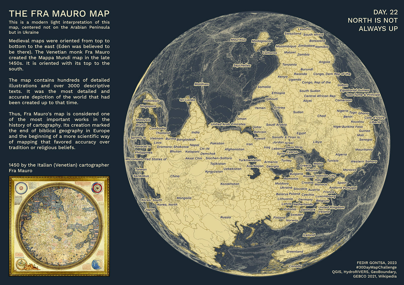
North
Day 22: North is not always up
#30DayMapChallenge The Fra Mauro map
This is a modern light interpretation of this map, centered not on the Arabian Peninsula but in Ukraine :-)
https://twitter.com/gontsa/status/1727485048671125514
https://mastodon.social/@gontsa/111457044395564382
Day 22: North is not always up
#30DayMapChallenge The Fra Mauro map
This is a modern light interpretation of this map, centered not on the Arabian Peninsula but in Ukraine :-)
https://twitter.com/gontsa/status/1727485048671125514
https://mastodon.social/@gontsa/111457044395564382

The third dimension
Day 23: 3D
#30DayMapChallenge
The Crimean Mountains
https://twitter.com/gontsa/status/1728890008675979529
https://mastodon.social/@gontsa/111478999001198958
Day 23: 3D
#30DayMapChallenge
The Crimean Mountains
https://twitter.com/gontsa/status/1728890008675979529
https://mastodon.social/@gontsa/111478999001198958

Only two colors allowed
Day 24: Black & white
#30DayMapChallenge
Carpathian Ukraine. 30 December 1938 – 15 March (May) 1939
https://twitter.com/gontsa/status/1728185632638284251
https://mastodon.social/@gontsa/111467993673709400
Day 24: Black & white
#30DayMapChallenge
Carpathian Ukraine. 30 December 1938 – 15 March (May) 1939
https://twitter.com/gontsa/status/1728185632638284251
https://mastodon.social/@gontsa/111467993673709400

A cold continent that can't be reached with Web Mercator
Day 25: Antarctica
#30DayMapChallenge
The Vernadsky Research Base
I recreated the 5-year-old project as far as possible from the picture. This is an experimental work from which I lost the source file.
https://twitter.com/gontsa/status/1728540011119649066
https://mastodon.social/@gontsa/111473530823672511

Less is more
Day 26: Minimal
#30DayMapChallenge
The Great Meadow, current state of the Dnipro riverbed
https://twitter.com/gontsa/status/1728845219981148659
https://mastodon.social/@gontsa/111478297070300104
Day 26: Minimal
#30DayMapChallenge
The Great Meadow, current state of the Dnipro riverbed
https://twitter.com/gontsa/status/1728845219981148659
https://mastodon.social/@gontsa/111478297070300104
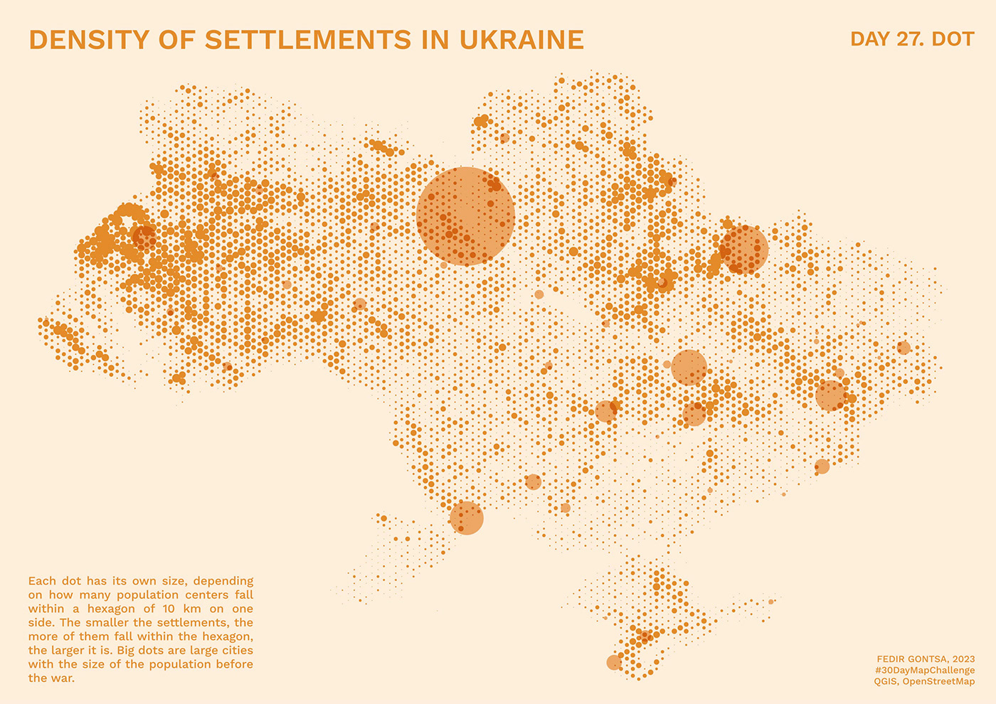
Dot density, a single dot in space or something different
Day 27: Dot
#30DayMapChallenge
Density of settlements in Ukraine
https://twitter.com/gontsa/status/1729257536572789185
https://mastodon.social/@gontsa/111484739736807848
Day 27: Dot
#30DayMapChallenge
Density of settlements in Ukraine
https://twitter.com/gontsa/status/1729257536572789185
https://mastodon.social/@gontsa/111484739736807848

In thematic maps, you can't always tell. Try to stretch the limits
Day 28: Is this a chart or a map?
#30DayMapChallenge
Results of demining of the territory of Ukraine by the SESU units for the entire period of war.
643 days of the active phase of the 9-year war
Data: the State Emergency Service of Ukraine
https://dsns.gov.ua/en/map-demining
Day 28: Is this a chart or a map?
#30DayMapChallenge
Results of demining of the territory of Ukraine by the SESU units for the entire period of war.
643 days of the active phase of the 9-year war
Data: the State Emergency Service of Ukraine
https://dsns.gov.ua/en/map-demining
https://twitter.com/gontsa/status/1729614036013040009
https://mastodon.social/@gontsa/111490309545594854
https://mastodon.social/@gontsa/111490309545594854
This scheme is based on a previous study of grid mapping for Ukraine. Also within the 30DayMapChallenge
https://twitter.com/gontsa/status/1326265553640546304
https://twitter.com/gontsa/status/1326265553640546304
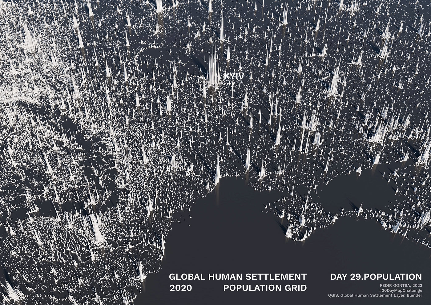
A classic theme for a map
Day 29: Population
#30DayMapChallenge
Global Human Settlement Population Grid, 2020
https://twitter.com/gontsa/status/1729984350387650758
https://mastodon.social/@gontsa/111496096478935502
Day 29: Population
#30DayMapChallenge
Global Human Settlement Population Grid, 2020
https://twitter.com/gontsa/status/1729984350387650758
https://mastodon.social/@gontsa/111496096478935502
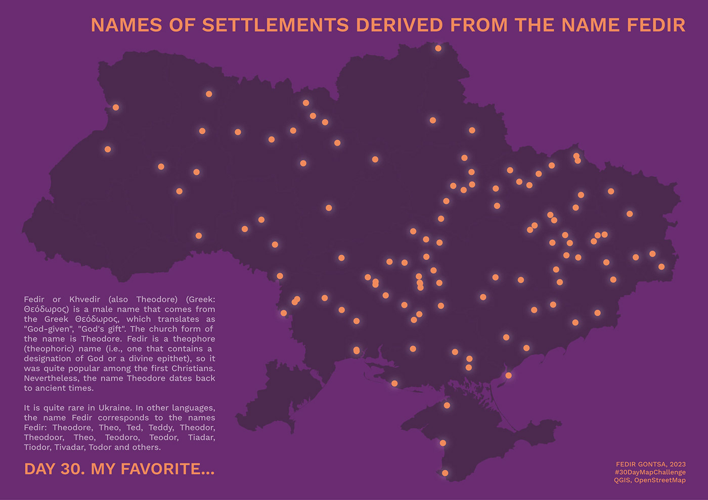
You choose!
Sooner or later, I had to do it ;)
Day 30: "My favorite.."
#30DayMapChallenge
Names of settlements derived from the name Fedir
https://twitter.com/gontsa/status/1730301888044716528
https://mastodon.social/@gontsa/111501054463379370
Sooner or later, I had to do it ;)
Day 30: "My favorite.."
#30DayMapChallenge
Names of settlements derived from the name Fedir
https://twitter.com/gontsa/status/1730301888044716528
https://mastodon.social/@gontsa/111501054463379370

That's all!
Thanks for watching all my work
over this incredible month!
over this incredible month!


