Locative Media User Experience Research
Index
Map 3: Mobile Mapping
Map 4: Final Map
Map 1: Mapping Words' Patterns
Map 2: Mapping as a Narrative
Map 3: Mobile Mapping
6 - Map III: Mobile Mapping
i- Map a network (audio, tweets, vids) of waypoints around the GNW site.
ii- Engage participation.
iii- Different way to experience the site.
By referring to the last three sentences I started brainstormng ideas for Map III.

I visited the Great Northern Way site. It was hard for me to imagine how my university will move
to this site in few years. The reason is that the GNW site is not as vibrant or interactive as Grandville Island.
Even the Master of Digital Media (MDM) building located in GNW seemed uninhabited althought there are 160 students studying there.

Relocating Emily Carr to this site, for me, is like giving life to a desert ... or to a phantom.
This thought reminded me of James Corner text: The Agency of Mapping. The relocation of the university,
can it be considered a form of superimposition of an independant space layer (Emily Carr) upon another one (GNW) resulting in a mosaic-like field of multiple orders, as Corner describes it.
can it be considered a form of superimposition of an independant space layer (Emily Carr) upon another one (GNW) resulting in a mosaic-like field of multiple orders, as Corner describes it.

Based on my experience at the site, the future relocation of EC, and Situationists appraoch to Layering, I decided to let people experiecne the site by superimposing two independant information layers. The first (bottom) layer is the map of the GNW site and the second (top layer) is tweets texts aggreagated from about ECUAD.

swisman urban design
Seeing the aggreagated #ECUAD superimposed on Emily Carr to-be campus will uncover a new layer of meaning.
I'm not yet sure how will I technically execute it.

Concept Sketch 1

Concept Sketch 2
I'll be happy to read all of your feedback.
Scroll all the way down and you'll find the comment box.
7 - Map III: Mobile Mapping: Part 2
After recieving feedback from Simon regarding my intial concept, I decided to alter it. The intial concept was about super-imposing a media content (tweets from emily carr) to a future space (the gnw site, where ECUAD will be after 4 years). The change that I'll make is in the temporal dimension of the media content; it'll be retrieved from the future.

tweet from the future
I used the mock-up of the architecure design of the new campus (executed by Suisman urban design) as the space to impose the tweets from the future. I added depth to the site picture using grids and displacment maps. Then went to the site again to recored the ambient sound that I'll use in the video.

adding depth
In this video model I want to let people experience the site by superimposing two independent information layers. The first (bottom) layer is the map of the GNW site and the second (top layer) is tweets texts aggreagated from/about ECUAD in th future.
–––––––––––––––––––––––––––––––––––––––––––––––––––––––––––––––––––––––––––––––––––––––––
Map 4: Final Map
9 - Mapping the unofficial record

The Known World, a map by Fra Mauro (1450)
Peter Turchi in his book "Maps of the Imagination" mentions Fra Mauro, a cartographer from the fifteenth century. Turchi refers to a novel in which the cartographer wanted to draw a map based not only on the knowledge about the world at the time but as well on the stories of travellers from around this world.

Description of Junk, Fra Mauro, 1450
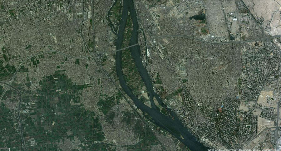
In the final map, I'd like to construct a map of a historically significant event based not on the official record, but on the people's record. The official being the state or professional media, and the people's being citizen media.

The map of the unofficial record, Cairo 2011
I'll aggragate citizen media videos captured in Cairo during a politically charged events, transform them into stills, then start synthesizing them. The result wil reveal the spaces and scopes that inform us about what and where, did events unfold, based on the citizen's record' that is citzen media.
10 - Mapping the unofficial record (Part II)
This week I put the plan of execution of the Map
Execution Plan is the following:
a- Picking a date from which I’ll aggregate the citizen video content
b- Aggregate videos from different locations
c- Exporting some of the aggregated videos, and constructing the videos’ reference map
d- Experimenting different ways to put the reference maps together.
b- Aggregate videos from different locations
c- Exporting some of the aggregated videos, and constructing the videos’ reference map
d- Experimenting different ways to put the reference maps together.
The map might reveal one or some of the following: where the witnesses were standing, the diversity of views capturing an event, the place of the event and how it changed over the course of the day (layering the change of the space, in relation to time).
A certain relations between, the visualization of the space, the plotting, and the event will be revealed, but it’s not yet definitive what are these relations.

a- Picking the date of the hitorical event
A- Picking a date: Feb 2 or Jan 27 or Jan 25 or Feb 11. The day was chosen based on the ease of verifying the event date and the video posting date. Hence, Jan 25, was the chosen date.

b- Aggreagating Content
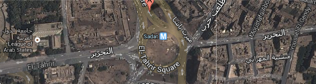
B- Aggregate videos from different locations in the same day. But that will probably make it harder to construct a map of them. So I'm thinking of aggregating from specific locations (Egypt > Cairo >> Tahrir)

Asking the people who captured the videos; where was it captured?
I asked the people who captured citizen videos, where was the video captured. But I didn't recieve any answers.

c- constructing the videos’ reference map

c- from night

c- from unknown location
Not knowing where the video was captured is an issue. It stands in the way of experimenting with the synthesize of reference maps.

Starting the experimentation process, I tried to relate/ detect where the different reference maps are located. Still some locations are unknown.
10 - Mapping the unofficial record (Part III & IV)
Starting from where I stopped last week. I decided to focus on one area and to aggreagate from it. The chosen area is the region of Tahrir square. The landmarks in the square's region is expected to facilitate the synthesize of the map.
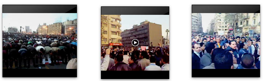
Started aggreagating the videos. I went throught the first 10 pages of google videos search. I used a specific formula to look up the videos that were uploaded on January 25. I chose the videos that were captured by citizens rather that news corporations. So all news reports were out of my selection. Some of them were captured in the day time and others in night time. At this stage I aggreagated both.
Surprisingly they weren't many. About 8 videos. That might be because I excluded the videos that might have been captured on January 25, but were uploaded a day after.
Some gepgraphical maps were used in the process, to help locate where the videos were shot and where the person who captured was standing.
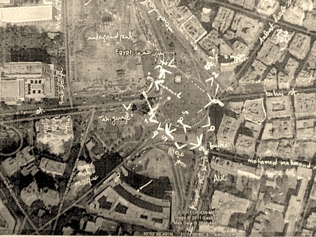
locating where the citizen videos were captured, and where the citizen was standing
Started construcitng pieces of the map. Stitiching and adjusting the stitching of the maps.


Hard and sometimes not possible to construct reference maps for vids captures at night.
Started looking at the refrence map and defining common landmarks, These were: Tahrir sq., complex building (mogama'), 18 Tahrir sq., and Hardee's Tahrir.

My map landmarks

Arranging the constructed maps in relation to a google map.

Using some photographs to double check the location of some landsmarks.

Aligning the different reference maps constructed earlier.

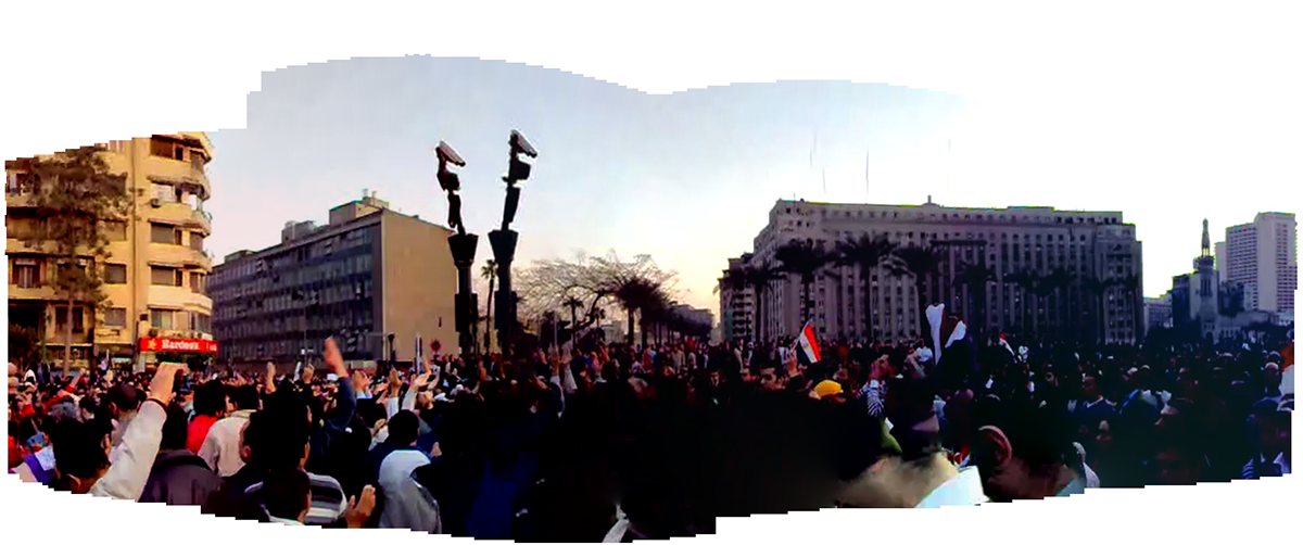
360 map of the square

10 - Mapping the unofficial record (Part V)
(Execution Plan is the following:
a- Picking a date from which I’ll aggregate the citizen video content >> 25/01/2011
b- Aggregate videos from different locations >> one location
c- Exporting some of the aggregated videos, and constructing the videos’ reference map >> night views were discarded
d- Experimenting different ways to put the reference maps together.)

Having a 360 of the square, and having checked all the previous steps in the execution plan,
I decided to Geo-register the 3 citizen videos that constructed the Reference Map earlier.

Three videos to geo-register


Close up on a geo-registered frame

1920 x 1080 refernce map occupying about the third of the canvas

the geo-registerd frame is tiny in comparison to the overall
It is a new modeling experience for me, as it is the first time to geo-register from an eye-level perspective, and on such a large reference map.
The first issue I faced is dimension of the video canvas, the scale, and the portion of the reference map to display within that canvas. As shown in the last snapshot, geo-registering the video on the entire reference map, will make it hard to get informed about the content of the videos.
The compromise was then to start with an establishing shot for the entire reference map, then zoom in on one part of the reference map where the video will be geo-registered.
I wanted to try to let the visuals take even a bigger portion of the screen, so I 'control+scroll' and screen recorded, to check if the results will offer a better viewing experience. The result was the following.

Scales: 100% and 125% (on right)

Scales: 125% and 150% (on right)
–––––––––––––––––––––––––––––––––––––––––––––––––––––––––––––––––––––––––––––––––––––––––
–––––––––––––––––––––––––––––––––––––––––––––––––––––––––––––––––––––––––––––––––––––––––
1- Course outline

Searching one of the four sites
2- Introducing maps and the first exercise
Class notes
Identifying the biases within maps. Mapping is so subjective. When mapping or reading a map, beware of the objective and subjective presentations. How can we think of cartography and counter-cartography. Each map tells a different story.
Terminologies
a- Field : that pulls the information (projection screen, chart, print)
b- Extracts : the info that we are using
c- Plotting : icons (bus, sea-bus)
Mapping # 1
I approached the context of this mapping exercise by reading testimonies of survivors from Indian Residential School (IRS) across Canada, speeches by Duncan Scott Campbell ( head of Indian Affairs Branch from 1913 to 1932), and reports of IRS investigators. In addition I watched a short documentary where survivors recalled what happened to them and looked at photos of the students.

Different medium
What I found intriguing that the two main parties involved in those incidents (school administrators and the Indian students) use a different medium to capture the past. School administrators captured it using photographs, and the students (who didn't have access to such a medium at the time) captured it in their memories. Therefore I became more interested in their written-spoken words and decided to discover word patterns in their testimonies, in the speeches of Campbell, and in the investigators reports.
The optimum way to look at such patterns is using word clouds. So I used a kids word cloud service, input the collected text each on its own.
Mapping Word Patterns

survivors

Duncan Campbell Scott
Mapping Gestures

3- Mapping Strategies | Finalizing Exercise 1
Mapping # 1
Last Friday I went to the PNE. There I listented to testimonies of IRS survivors. It was a very emotional experience.

Friday 20, September, 2013. PNE
I resumed working on the first mapping exercise. I had some aspects that I wanted to consider and including the feedback it recieved during the last class. I started reading more testimonies from IRS survivors, as well as more statments from Scott Duncan Campbell. I added them to the existing ones I had, then input them to the word cloud.

Using the Visual Thesarus to explore word(s) and its relation to other concepts within a text
(Survivors text on the right, Campbell on the left)

one of the trials considering some of the feedback
–but it didn't allow enough readibility for the content
I chose the 'courier' font. As it resembles the output of a typewriter, the 'courier' font is associated with official documents (it was the font used by the the US State Department til 2004). The intention behind using it
is to validate the unofficial records; the memoires and words of the survivors. The same font was used for both to facilitate the comparison and examination process of both. The timeline of both the testimonies and the state statments were indicated to draw attention to the effects that statments and law acts caused.
is to validate the unofficial records; the memoires and words of the survivors. The same font was used for both to facilitate the comparison and examination process of both. The timeline of both the testimonies and the state statments were indicated to draw attention to the effects that statments and law acts caused.

4- Mapping as a Narrative
Class Notes
Triangulation, three satellite to pull information. Geo caching. Treasure hunting. Psycho-Geography
Triangulation, three satellite to pull information. Geo caching. Treasure hunting. Psycho-Geography
How can mapping be a cultural activity? How to reveal interesting aspects, through un-traditional ways
How can it be more engaging?
How can it be more engaging?
Precedent works
- San Francisco emotion map, Christian Nold, 2007
- Arthur Clark belt
- Arthur Clark belt
Mapping Exercise # 2
Create a narrative on a geographical space
Create a narrative on a geographical space
Collect points of interests
Find something engaging to think about
You can take away people’s extracts, re-think them
Use online mapping tool to tell a life story (not necessarily yours)
It has to have a clear methodology
Icons in gmaps. Embed sounds
You can take away people’s extracts, re-think them
Use online mapping tool to tell a life story (not necessarily yours)
It has to have a clear methodology
Icons in gmaps. Embed sounds
(i.e. Places you are scared of. Follow software glitches. Mark dark dots and go there.)
Mapping Exercise Concept

The narrative that I'm interested in unfolding is dated 10 years back in the past. Located in Cairo, the capital city of Egypt. People mistake the events of the 25th of January Revolution that it suddenly took place, or an effect of the revolution in Tunisia (18 Dec 2010-14Jan2011). Many usually think that the start of 'breaking the silence' in Egypt started on January 25, 2011. I disagree with two widely spread ideas about the January revolution; first its start date (that's believed to be on January 25, 2011) and second its end date (February 11, 2011). Hence most of the exisitng info-graph based maps are concerned with a specific day (between Jan 25 - Feb 11) or a major event that occurred afterwards.

Narratives have beginning, middle (climax), and end.
My narrative map traces and tell the story of a number of protests and strikes that took place 10 years before the January 2011. Such protests played an important role in promoting the culture of peaceful protests and encouraging citizens to break their fear from speaking out.
I'll use a geographic map to track and tell the story of small protests that took place in various cities of Egypt. These small-in-numbered protests deserve to shed the light on their effect.
I'll use a geographic map to track and tell the story of small protests that took place in various cities of Egypt. These small-in-numbered protests deserve to shed the light on their effect.
Cairo
5- Protests that preceeded the Spring
